Queenstown Hill Time Walk
OpenChecked 18 Sept 2026
- Time
- 2 to 3 hreturn
- Distance
- 5.4 kmreturn
- Grade
- Easy to intermediate walking trackDOC's grade
- In winter
- Care needed
Highest on the line840 mat 2.8 km
Published: climb about 500 m; high point about 840 m.
Shaded: the steepest kilometre, 1 in 6. Drag along the profile to follow the track on the map.
Another 0.6 km of side track is on the map but not in the profile.
How this line was drawn
Heights from LINZ 8 m elevation data (CC BY 4.0) along the OpenStreetMap track line. LINZ interpolated them from 20 m contours, so they are good to about 10 m.
Starts atCar park off Belfast Terrace
Directions (opens in a new tab)BusRoute 4 at Boundary St, about 400 m from the start
Bus times
Track line and lake outlines © OpenStreetMap contributors (ODbL). Contours from LINZ 8 m elevation data (CC BY 4.0).
In short: The Queenstown Hill Time Walk is 5.4 km return and takes 2 to 3 hours, climbing about 500 m from a small car park off Belfast Terrace, past the Basket of Dreams, to the rock tors at the top of the track, about 840 m up. DOC's brochure grades it an easy to intermediate walking track. The council manages it, and dogs are not allowed.
About this walk
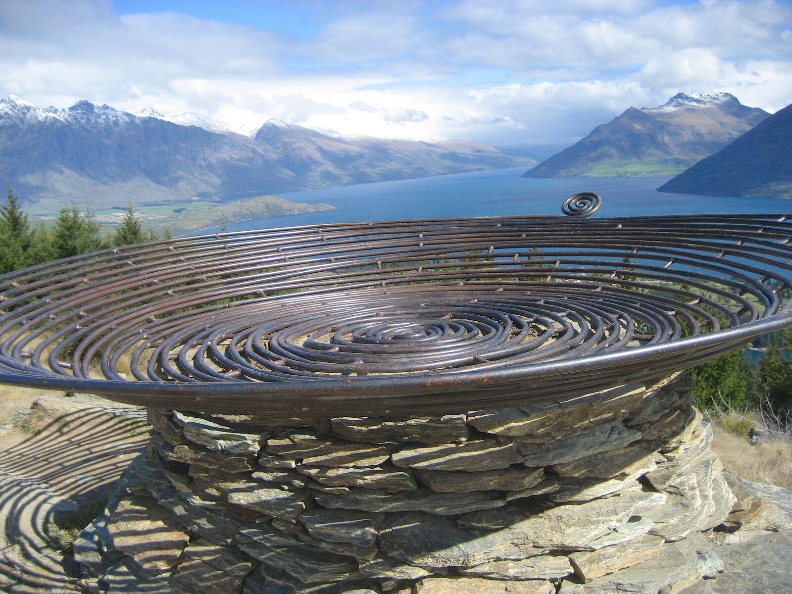
A steady climb through pine forest from Belfast Terrace to the Basket of Dreams sculpture and a summit view over the Whakatipu basin, close to the town centre.
By Queenstown Pocket · Published 4 Sept 2026
Take this walk with you
All 50 walk guides with the track map, offline, and every Orbus bus time.
 On a laptop?
Scan with your phone.
The facts in full
- Time
- 2 to 3 hours return
- Distance
- 5.4 km return
- Track type
- Return the same way
- Climb
- about 500 m, high point about 840 m
- Grade
- Easy to intermediate walking track
- Winter
- Care needed in winter
- Dogs
- No dogs
- Children
- About 500 m of climbing over 2 to 3 hours return (DOC)
- Cost
- Free
What the track is like
Six information panels on Queenstown's history on the way up, a small tarn ringed by bog pine, the Basket of Dreams sculpture by Caroline Robinson at the top of the loop, and rock tors at the summit with a 360-degree view over The Remarkables, Cecil Peak, the Frankton Arm and Queenstown Bay.
The track leaves the small car park off Belfast Terrace, where a council sign marks the start, and climbs through pine forest. Destination Queenstown describes six information panels along the way, each covering a period of Queenstown's history from Māori settlement through the gold rush to the town today.
Further up, the track passes a small tarn with bog pine around it and reaches a short loop, with the Basket of Dreams sculpture at its top. The sculpture is a sensible place to turn around if time, weather or legs run short. From the loop the track climbs on toward the summit; Destination Queenstown says an even better view waits about 0.5 km further up the walkway.
At the top, about 840 m up, rock tors make natural seats for the view. DOC's map marks the hill's highest point, 907 m, further along the ridge; the walk stops at the tors. Return the same way. DOC puts the whole walk at 5.4 km and 2 to 3 hours return with about 500 m of climbing, so allow the full 3 hours if you are unsure of your pace.
DOC and Destination Queenstown both note that this council-managed track crosses private or leased land. Keep to the track, give stock plenty of room and leave any gate the way it was.
How to get to the start
The walk starts at a small car park off Belfast Terrace, not far from the town centre; DOC's brochure map marks parking there and a council sign marks the start. The car park is small, so walking from town is worth considering.
Orbus Route 4 stops at Boundary St, about 400 m from the car park, and Routes 1, 4 and 5 stop at Stanley Street Bus Hub B (Playcentre), about 500 m away. Fares are $2.50 with a Bee Card.
- Start: Car park off Belfast Terrace (directions (opens in a new tab)).
- Parking: Small car park off Belfast Terrace, marked by a council sign (Destination Queenstown)
- By bus: Orbus Route 4 stops at Boundary St, about 400 m from the Belfast Terrace car park, and Routes 1, 4 and 5 stop at Stanley Street Bus Hub B (Playcentre), about 500 m away. Routes and fares are in the bus guide.
Is it open, and what is it like in winter?
Open on 18 September 2026. The council's list of trails closed or needing care after the late August 2026 storm does not include Queenstown Hill (read 18 September 2026), and no other closure was found. DOC's brochure warns that higher-altitude tracks in the area can carry snow and ice from autumn through winter and often into spring. Check Queenstown Lakes District Council, Latest update on Queenstown Lakes weather event (28 August 2026) (opens in a new tab) on the day; conditions change quickly.
| Season | What to expect |
|---|---|
| Spring (September to November) | DOC's brochure warns that higher-altitude tracks in the area can carry snow and ice from autumn through winter and often into spring, so in September and October be ready for icy patches on the upper slopes. Check the forecast: DOC says the weather here changes quickly at any time of year. |
| Summer (December to February) | Destination Queenstown rates it a year-round walk. The lower climb is under pine forest but the top is open above the treeline, so carry water, a hat and sunscreen on a hot day. |
| Autumn (March to May) | Shorter days: start at least three hours before dark so the full return fits in daylight. DOC notes snow and ice can return to the higher tracks from autumn. |
| Winter (June to August) | Destination Queenstown says there may be snow in winter and to wear shoes with good grip. Most of the climb is under pine forest; the open ground higher up is more exposed and can be frozen, so turn back if the upper slope is icy. |
What to know before you go
- No dogs are allowed on this track (DOC brochure symbol).
- Above the pine forest the slopes are open to wind, sun and snow. DOC warns that higher-altitude tracks in the area can hold snow and ice into spring, and Destination Queenstown advises shoes with good grip in winter.
- The weather in the Whakatipu changes quickly at any time of year (DOC): carry a warm layer and a rain jacket even when it is clear in town.
- Allow the full 3 hours and start early enough to be back before dark; take a headtorch in the shorter months.
- The track crosses private and leased land: keep to the track and leave gates as you find them.
- Check QLDC's parks and walkways page for closures before you go.
For emergencies call 111. The Queenstown safety guide covers the rest before a long or winter walk.
Questions people ask
How long does the Queenstown Hill walk take?
2 to 3 hours return for the 5.4 km walk from Belfast Terrace to the summit and back, according to DOC, with about 500 m of climbing.
How far is the summit from the Basket of Dreams?
The Basket of Dreams sits at the top of a short loop below the final climb. Destination Queenstown says an even better view is about 0.5 km further up the walkway; no source publishes a separate time to the sculpture.
How hard is Queenstown Hill?
DOC grades it an easy to intermediate walking track with about 500 m of climbing to the top of the track, about 840 m up. Destination Queenstown says medium to high fitness is required.
Where does the Queenstown Hill track start, and where do I park?
At a small car park off Belfast Terrace, marked by a council sign. The car park is small, so walking from town is worth considering.
Can I walk Queenstown Hill in winter?
Yes, with care. Destination Queenstown says there may be snow in winter and to wear shoes with good grip, and DOC warns higher-altitude tracks can hold snow and ice into spring. Turn back if the upper slope is icy.
Are dogs allowed on Queenstown Hill?
No. DOC's brochure marks the Queenstown Hill Time Walk as no dogs.
Can I get to Queenstown Hill by bus?
Yes. Orbus Route 4 stops at Boundary St, about 400 m from the Belfast Terrace car park, and Routes 1, 4 and 5 stop at Stanley Street Bus Hub B, about 500 m away. Fares are $2.50 with a Bee Card.
Nearby walks
Get the app
Queenstown Pocket carries all 50 walk guides with the track map, the bus stop and the toilets, offline.
Related guides
 Planning
Free things to do in Queenstown
Twelve free things, and the $2.50 bus that gets you to each one.Checked 5 Nov 2026 Planning
Queenstown with kids: child prices, the free stuff and the buggy-friendly walks
What the big activities charge for children, the $1.50 bus, the Gardens and the Frankton Track, and the rain plan.Checked 5 Oct 2026 Planning
Queenstown safety: the numbers, the hills, the roads and the lake
111 and 105, the Land Safety Code, chains, the 10-degree lake, and why ACC is not travel insurance.Checked 9 Sep 2026
Photographs are credited on each guide and on the photo credits page.
Sources: DOC, Queenstown day walks and bike trails brochure (March 2025), track 13 and map (opens in a new tab), Destination Queenstown, Queenstown Hill Time Walk (opens in a new tab), Destination Queenstown, Best short walks in Queenstown, ranked by difficulty (opens in a new tab) and Queenstown Lakes District Council, Latest update on Queenstown Lakes weather event (28 August 2026, trail closures and cautions) (opens in a new tab), retrieved 18 September 2026. Distances, times and grades are the managing body's published figures; fit walkers are often quicker. Department of Conservation information is used under CC BY 4.0. Start coordinates: OpenStreetMap contributors (ODbL). This independent guide is published by Tally Sphere Limited, a New Zealand company. Spotted a change? Report a problem with this page and the page address comes with your email.
All walks: Queenstown walks and tracks.